Navigate forests.
No signal
required.
A bare-minimum roadbook display for motorcycle trips. Plan waypoints at home, export a JSON, import on your phone, ride. No live maps. No accounts. No tracking.
How it works ↓
 340 m
340 mSee it in action
22 seconds. Plan, load, ride.
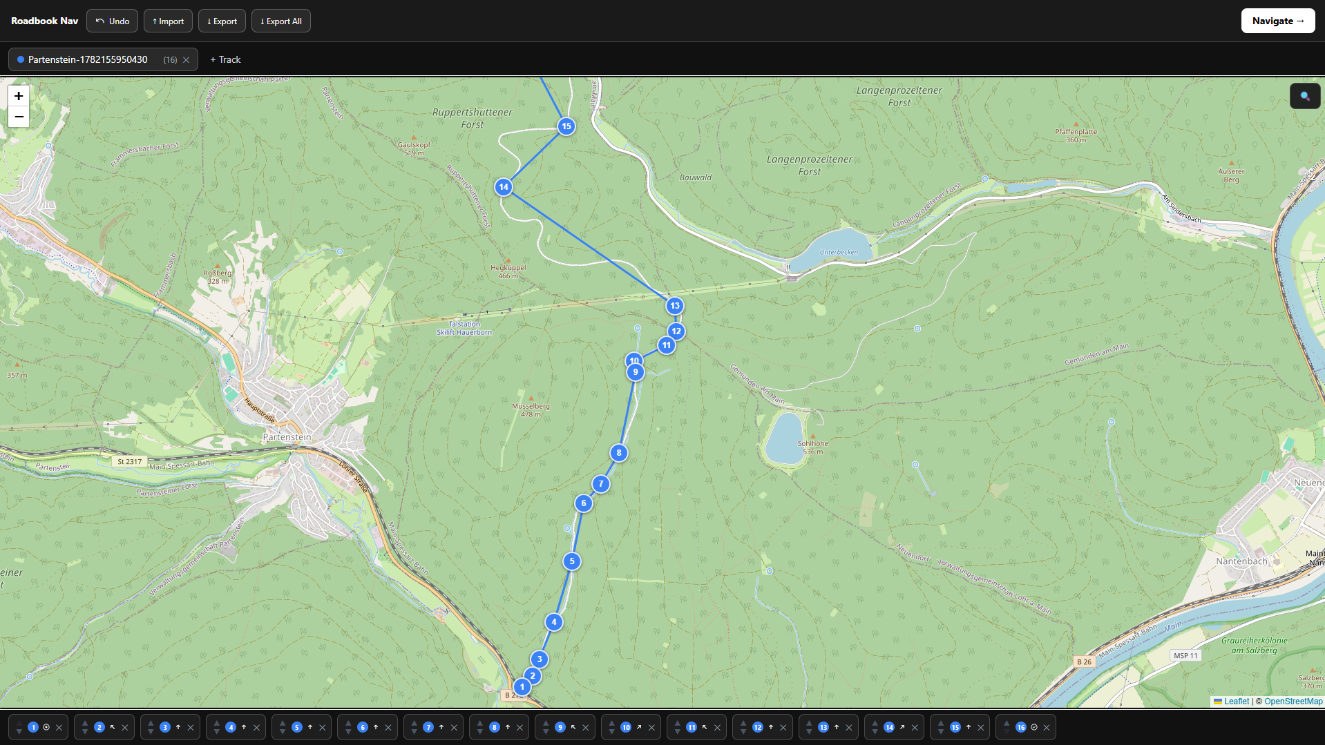
Route editor
Build your route at home.
The editor runs in your browser — no install, no account. Drop waypoints on a live map, assign a direction to each turn, then export a single JSON file. That file is everything the navigation needs.
- —Click to place Drop a waypoint on the map and pick a turn direction. Nothing else required.
- —Drag to adjust Reposition markers directly on the map or reorder them in the strip below.
- —Multiple tracks Build route variants side by side and switch between them instantly.
- —Export and go One JSON file per route. Import it on your phone in two taps.
How it works
Plan
Open the map editor at home. Click to place waypoints. Assign a direction to each — straight, bear left, sharp right, U-turn. Save your route as a file.
Load
Open the app on your phone and import the saved file. Two seconds. No sync, no cloud, no account required.
Ride
A full-screen arrow and a live distance countdown. At 25 m from each waypoint, the display advances automatically and the phone vibrates.
What it doesn't do
- —Fetch map tiles while navigating
- —Send your location anywhere
- —Require an account or sign-up
- —Store data outside your own device
- —Work as a turn-by-turn road navigator
Under the hood
- DistanceHaversine formula, pure JavaScript
- Trigger radius25 m around each waypoint
- ScreenWakeLock API keeps the display on
- Hapticsnavigator.vibrate(400) at each point
- StoragelocalStorage — no server involved
- BuildNext.js static export, runs anywhere
Install it before you leave
Offline only works
when installed.
The navigation mode has zero network requirements — but your browser only grants full offline capability to apps installed on the home screen. Add it once at home, and it works without a signal anywhere.
The map editor still needs internet to load OpenStreetMap tiles. Use it at home, then install and go.
Your device
Or open the app directly
Open in browser →Works without installing, but requires internet for navigation in this mode.
FAQ
How does motorcycle navigation work without internet in a forest?
You plan the route at home with a regular internet connection (the map editor needs tiles). Export a JSON. On your bike, import it into the app — from that point the only thing running is the GPS receiver in your phone and a distance formula. No pings, no tiles, no fallback API.
What is a digital roadbook?
The paper tulip cards strapped to rally handlebars, digitised. Each card shows one instruction — a direction and a distance. This app does the same thing on a phone screen, advances automatically as you ride, and keeps it to the minimum: one arrow, one number.
Does it work as a PWA / installable app?
Yes. Add it to your home screen from your mobile browser. The navigation mode runs entirely offline. The map editor requires internet to load OpenStreetMap tiles, so use that at home before you leave.
No install required. Runs in the browser.
Open Roadbook Nav →